
A highway closure does not wait for the morning planning call. It shows up as a red marker, a stopped truck, a driver asking whether to sit or turn, and a delivery appointment that starts losing shape minute by minute. For fleets moving retail, food, industrial parts, parcel linehaul, or intermodal drayage, the useful question behind AI for supply chain disruption during a highway closure is not whether a model can “see” traffic. It is whether the system can detect the closure early enough, recalculate the arrival impact, and put a workable alternate route in front of the dispatcher or driver before the first bad decision becomes the day’s operating plan.
The cost base is already large before a single unusual incident is added. ATRI estimated that U.S. highway congestion cost the trucking industry $108.8 billion in 2022, up 15% year over year, with 6.4 billion gallons of diesel wasted and an average annual congestion cost of $7,588 per registered combination truck. The top ten states accounted for 52% of those congestion costs, led by Texas, California, and Florida.[1] That is recurring drag. A sudden closure adds a different problem: the clock starts converting uncertainty into detention risk, missed delivery windows, empty miles, service failures, and downstream rescheduling.
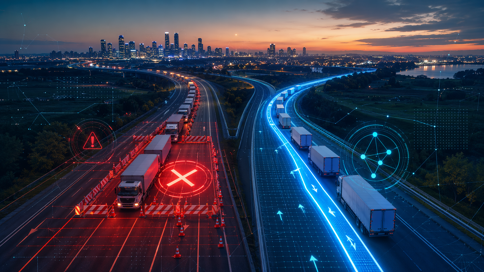
Small closure examples matter because they are close to how dispatch teams actually feel the day. InQuik, citing Oregon DOT value-of-time methodology, describes a one-hour unexpected road closure affecting 600 vehicles as generating about $24,000 in delay costs.[2] That is not a national freight average, and it is not a claim that every closure carries the same cost. It is a useful operating picture: a short interruption, a finite number of vehicles, and enough cost to justify faster detection if the route choice can still change.
Larger disruption modeling shows why network context also matters. A 2021 Virginia highway-network analysis reported single-day economic losses ranging from $8 million in a mild three-hour delay scenario to $256 million in a severe hurricane-evacuation scenario.[3] That range should stay in its lane: it is Virginia-specific and scenario-based, not a current national benchmark. Its value is that it shows how quickly road disruption costs depend on duration, location, traffic composition, and whether the affected corridor has practical substitutes.
What has to happen in the first few minutes
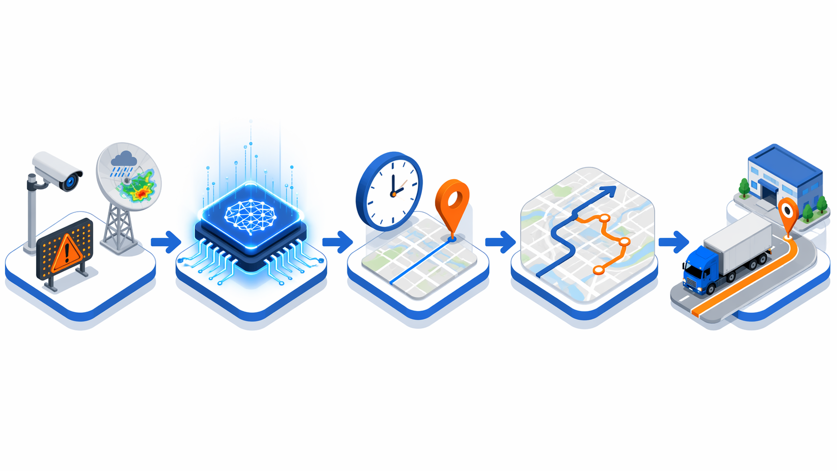
Dynamic rerouting is often described as if the route engine is the whole story. In practice, the first few minutes belong to detection and matching. The system has to notice that something has changed on the road, decide whether the change affects active loads, estimate how long the delay will matter, and separate a genuine closure from noise that would only distract dispatch.
| Operating moment | What the AI-enabled workflow needs to do |
|---|---|
| Closure signal appears | Ingest traffic speed changes, incident reports, DOT alerts, weather signals, and map restrictions. |
| Affected freight is identified | Match the event against live GPS telematics, planned routes, appointment times, service rules, and equipment constraints. |
| ETA impact is recalculated | Compare the current route with historical congestion patterns, expected clearance behavior, hours-of-service limits, and stop sequence commitments. |
| Alternates are ranked | Recommend routes that are legal, feasible, and operationally better than waiting. |
| Execution is pushed | Send the decision into the dispatcher workflow, driver app, TMS, or control tower with enough context to act. |
The live traffic layer is one of the earliest inputs. Commercial traffic-data products such as INRIX AI Traffic are positioned around real-time road-speed and traffic-state intelligence that can feed navigation, planning, and incident response systems.[4] On its own, that layer can tell a system that the road is behaving badly. It does not automatically know whether a temperature-controlled load is about to miss a receiver appointment, whether the driver can legally take a different corridor, or whether a customer must be notified before the appointment collapses.
That is where the route optimization layer becomes useful. Blue Yonder describes route optimization capabilities that use AI traffic prediction to proactively reroute fleets when a highway closure or storm is detected, and positions cognitive route execution as a way to connect route optimization with supply planning.[5] The important part is not the phrase “AI traffic prediction.” It is the connection between the external event and the internal plan: which truck, which stop, which appointment, which route rule, which customer consequence.
Detection is only useful when it changes the dispatch window
A closure alert that arrives after the driver has already committed to the trapped segment is visibility, not prevention. The practical workflow starts before that point. The system compares the live route against closure geometry, milepost-level incident data where available, weather-driven risk, and traffic-speed decay. If the truck is still upstream of a usable decision point, the AI can evaluate whether exiting early, taking a parallel corridor, resequencing stops, or holding at a safe location creates the lowest total operating damage.
The ETA calculation has to be redone at the load level, not just the map level. A fifteen-minute road delay may be irrelevant for a flexible drop trailer and expensive for a live unload with a strict receiver gate. A longer alternate route may protect a must-arrive delivery but create an hours-of-service problem before the next stop. A route that looks faster on a map may not be legal for the equipment or desirable for hazardous material, oversize freight, local restrictions, or customer-specific routing rules.
This is why ETA quality deserves more attention than dashboard polish. project44 says its Movement platform delivers predictive ETAs with more than 90% accuracy within a two-hour window on the final delivery day and reports a 28-percentage-point improvement in truckload accuracy; that should be read as a vendor benchmark, not an independent proof that every highway-closure rerouting deployment will perform the same way.[6] Still, the right metric category is clear. Logistics teams need to know whether the ETA changes early, whether it stays stable enough to trust, and whether it reflects road events quickly enough for appointment management.
In a working control-tower flow, the dispatcher should not have to chase four screens to decide what happened. The closure signal, affected loads, estimated delay, recommended alternate, customer impact, and driver instruction should land together. If the system recommends a reroute, it should explain the tradeoff in dispatch terms: added miles, expected arrival recovery, fuel impact, appointment risk, and any constraints the planner must approve. A driver should not be handed a mysterious blue line with no reason and no exception handling.
Adjacent disruption use cases follow the same pattern. Weather-triggered routing depends on fusing forecast, road, and vehicle data, as discussed in AI weather alerts for logistics routes. Infrastructure-specific cases, such as AI route optimization for Tacoma Narrows Bridge supply chain disruptions, are useful comparisons because they show the same operating question in a narrower setting: can the system spot the constraint early enough to route freight around it instead of documenting the delay afterward?
The measurable outcomes are narrower than the sales deck
A fleet should not evaluate highway-closure AI by asking whether AI reduces logistics cost in the abstract. The cleaner question is which part of the closure response changes. Did the system detect the incident before the dispatcher’s manual scan? Did it identify all affected loads? Did it reduce late arrivals among trucks that still had a viable alternate? Did it cut check calls and customer-service escalations? Did it prevent avoidable detention, or simply move the delay to a different part of the day?
- Time from closure occurrence to usable alert in the operations workflow.
- Share of in-transit loads correctly matched to the affected road segment.
- ETA error before and after the closure signal enters the model.
- Number of loads rerouted before the final practical decision point.
- Reduction in manual dispatcher touches, customer exception calls, detention events, and missed appointments.
Fuel and labor still matter, but they should be tied to actual reroute decisions. ATRI’s congestion data gives the national scale of wasted diesel and truck delay, but an individual fleet needs lane-level evidence: which routes had closure exposure, which alternates were chosen, what extra miles were added, how much waiting time was avoided, and whether the customer service outcome improved.[1] Without that chain, a broad savings claim can hide the fact that the model only worked on the easy cases.
There are also cases where the best answer is not to reroute. If every alternate is blocked, unsafe, illegal, or likely to miss the same appointment anyway, the system may create more value by triggering customer notification, resequencing, yard planning, or labor rescheduling. A good highway-closure workflow should be allowed to recommend “hold and notify” when moving the truck only burns fuel and driver hours.
The integration gap decides who gets the benefit
The use case is deployable today, but it is unevenly effective because many logistics operations still run with broken data seams. A GEODIS survey found that only 6% of companies reported full end-to-end supply chain visibility.[7] For highway-closure rerouting, that missing visibility is not an abstract maturity problem. It means the route engine may not know the current truck position, the TMS may not receive the updated ETA, the customer portal may show old status, the carrier may be making its own call, and the dispatcher may still be reconciling the truth by phone.
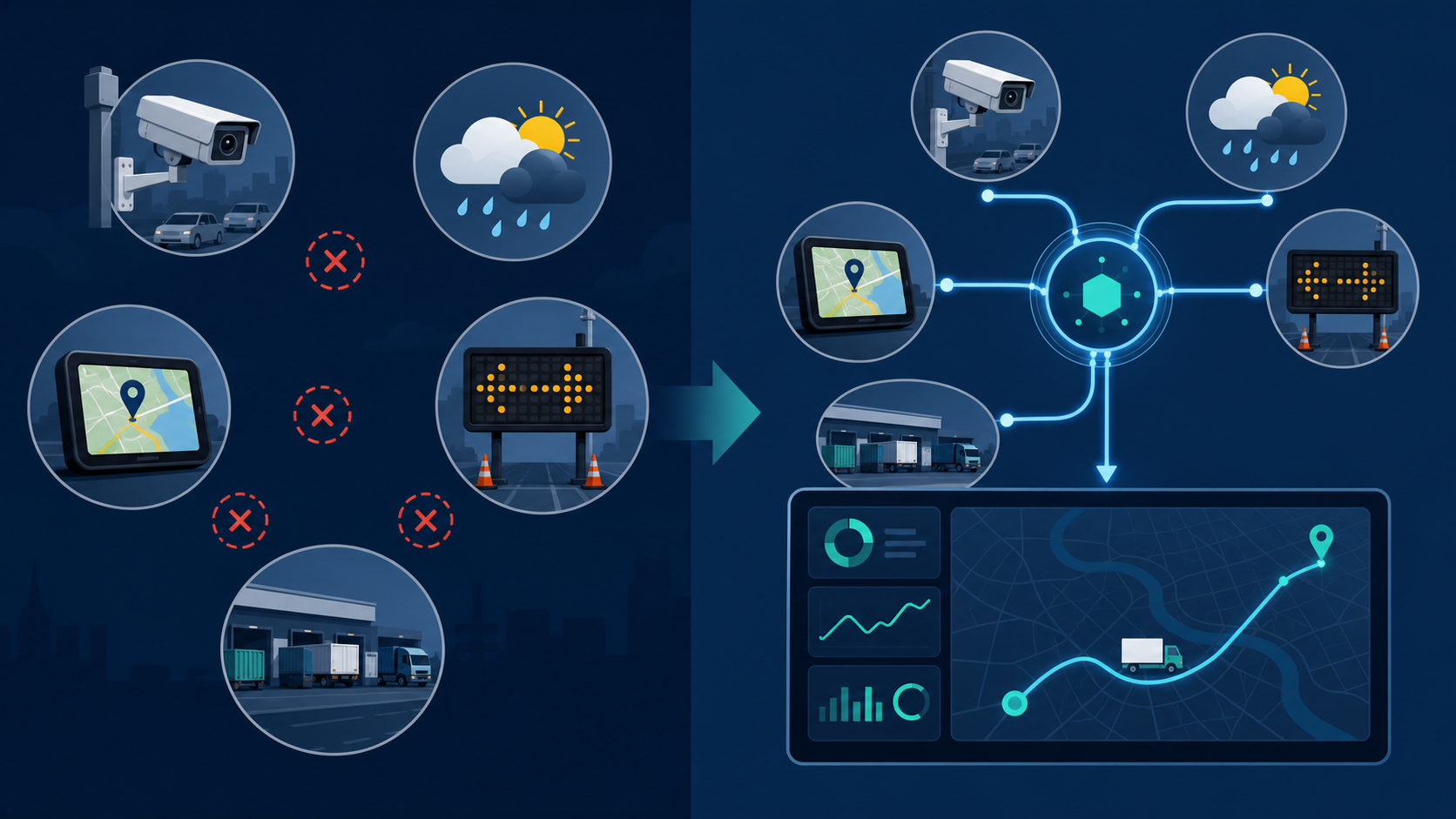
That is the uncomfortable buying lesson. A stronger model will not rescue a weak execution layer. If the platform ingests public traffic feeds but not carrier telematics, it may detect the closure without knowing which loads are exposed. If it recalculates ETA but cannot write back into the TMS, the dispatcher still has to copy the answer into the operating system. If the driver app and broker visibility feed disagree, the customer receives noise instead of a credible recovery plan.
Latency is the first implementation test. Logistics leaders should ask how often each feed updates, how the platform handles delayed GPS pings, whether DOT closure data is normalized across states, and how quickly a road-speed anomaly becomes an actionable exception. A closure detected in the traffic layer but surfaced to dispatch twenty minutes later may still look impressive in a demo. It may not save the load.
Coverage is the second test. The routing system needs traffic, incident, weather, GPS telematics, order commitments, appointment windows, equipment restrictions, customer rules, and carrier execution status. Weather belongs in the closure conversation because flooding, ice, wind, fire, smoke, and evacuation traffic can change road availability before a formal closure notice catches up. The same detection discipline appears in adjacent patterns such as AI wildfire smoke supply chain disruption detection and AI hurricane supply chain planning, where the model’s value depends on connecting external hazard signals to specific freight decisions.
Workflow fit is the third test. The alert should arrive where the work happens, not in a separate analytics product that someone checks after the rush. A private fleet may need the decision in its dispatch console. A shipper working through carriers may need exception status, revised ETA, and customer notification triggers. A 3PL may need both: the carrier instruction path and the shipper-facing control tower record. ABI Research reported that 65% of supply chain professionals see AI or GenAI as important or very important for technology purchase decisions, and that control towers are becoming “non-negotiable” in 2026.[8] That purchase pressure is real, but the highway-closure use case still has to pass the operating desk.
How to evaluate highway-closure AI before rollout
The pilot should be built around lanes and events, not around a generic AI score. Pick corridors where closures, congestion, weather, or infrastructure constraints have created recurring service pain. Establish the current baseline: how dispatch learns about incidents, how long it takes to identify affected loads, how ETAs are updated, how many manual touches occur, and what detention or missed-appointment costs follow. Then test whether the AI-enabled workflow changes those moments.
- Ask vendors to show data latency by source, not just a list of connected feeds.
- Require evidence that closure alerts are matched to live loads, appointment windows, and route constraints.
- Compare ETA recalculation quality during incidents, not only during normal traffic.
- Test whether recommendations reach the dispatcher, driver, carrier, and customer systems without rekeying.
- Separate avoided delay from shifted delay, added miles, and customer-notification improvement.
The same evaluation logic applies inside a broader disruption-planning roadmap. A team deciding which capabilities to fund first can place highway-closure detection alongside weather alerts, infrastructure constraints, cyber or physical infrastructure threats, and pre-positioning decisions; broader frameworks such as AI capabilities for disruption planning and AI supply chain disruption planning for infrastructure attacks are useful when the question moves from one road event to portfolio-level resilience.
AI highway-closure detection and dynamic rerouting is no longer a speculative future capability. Fleets can use it now to reduce avoidable delay when the data and workflow are ready. The winning condition is not the model alone. It is the ability to fuse live traffic, DOT incident and closure data, weather signals, GPS telematics, historical congestion patterns, order commitments, and execution status fast enough that the reroute reaches the right person before the closure becomes a cost event. Evaluate the use case by data latency, integration coverage, ETA recalculation quality, and execution workflow fit; generic AI claims will not move a truck out of a closing lane.
References
- Trucking's Annual Congestion Costs Rise to $108.8 Billion, ATRI, December 2024
- InQuik LinkedIn post citing Oregon DOT value-of-time methodology, InQuik
- USA: Highway delays can cause economic losses $250 million per day, PreventionWeb
- Real-Time Traffic Data, INRIX AI Traffic
- What is Route Optimization?, Blue Yonder
- Using Predictive ETAs to Reduce Costs, project44
- GEODIS survey on end-to-end supply chain visibility, GEODIS
- Supply Chain Disruptions 2026: How to Build Resilience with AI and Automation, ABI Research
Comments
Join the discussion with an anonymous comment.