
For an Asia-Europe logistics desk, the Northern Sea Route is not interesting because it looks dramatic on a polar map. It is interesting because the line is shorter. A voyage between East Asia and Western Europe that is roughly 21,000 km through Suez can be about 12,800 km by the Northern Sea Route, with a commonly cited transit-time advantage of 10 to 15 days when the route is usable.[1] That is the commercial opening for AI-driven Arctic route optimization: not a promise that the Arctic is suddenly easy, but a way to decide when the shorter line is safe enough, fuel-efficient enough, insurable enough, and suitable for the vessel actually being dispatched.
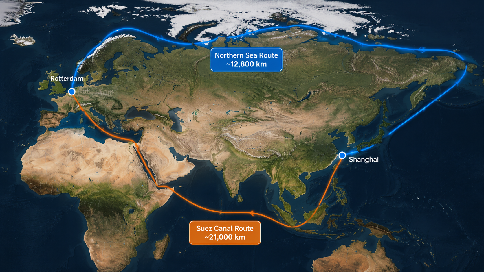
The old NSR question was seasonal and binary: can the ship go, or should it stay with Suez? The newer question is more operational. Given a specific hull, cargo, charter schedule, ice outlook, bunker price, emissions target, insurance position, and Russian administrative exposure, does the Arctic route beat the conventional route after the risks are priced in? AI matters because it lets that question be asked as a trade-off, not as a sales slide.
The evidence is now strong enough to justify serious planning for selected vessels and cargoes. AI weather routing has been reported to cut fuel use by up to 17% in Arctic operating contexts, while Orca AI says its maritime optimization tools deliver 3% to 5% annual fuel savings per vessel and return on investment within three months of fleet deployment.[2][3] Those are not the same kind of evidence: the first is a route and weather-routing outcome, the second is a vendor-reported fleet economics claim. Together, they indicate why operators are paying attention, but they do not remove the need to test each lane, season, vessel class, and data environment.
The Commercial Case Starts Before the Vessel Sails
A credible Arctic routing workflow starts weeks or months before departure. It does not begin with a single optimized track. It begins with a planning envelope: which days of the year are likely to be navigable for the vessel class, where ice concentration may close the practical corridor, what icebreaker support may be needed, and whether the cargo can tolerate schedule variability.
Market forecasts are part of that planning pressure. HTF Market Intelligence projects the Arctic shipping routes market to grow from $13.8 billion in 2025 to $31.6 billion in 2033, a 9.6% compound annual growth rate, and reports roughly 18% voyage-efficiency gains on NSR operations.[4] The forecast is useful as a signal of market attention, not as proof that the route has become easy. Single-source market reports and vendor materials tend to compress the messy middle of operations: permits, ice pilots, hull restrictions, communications, insurance, port calls, and a master’s tolerance for a forecast that may deteriorate mid-voyage.
For the route planner, the early decision is not simply NSR versus Suez. It is whether the NSR deserves a slot in the voyage plan at all. That decision depends on the distance advantage, the ice forecast, the ship’s Polar Code capability, the need for escort, and the commercial value of arriving earlier. A high-value cargo with schedule pressure and an ice-class ship may clear that bar. A standard open-water vessel with thin margins and limited Arctic support usually should not.
What the AI Stack Actually Does
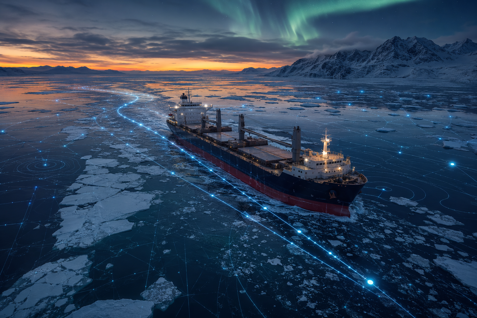
The useful AI stack for Arctic routing is not one model. It is a chain of models and decision tools that narrow uncertainty at different time horizons. Long-range ice-presence models help planners decide whether an Arctic option belongs in the schedule. Short-range ice forecasts support tactical routing. Optimization engines generate and score candidate tracks. Computer vision and image-enhancement tools help bridge teams and autonomous systems interpret low-visibility conditions. During the voyage, the plan has to be revised as ice, weather, fuel consumption, traffic, and support constraints change.
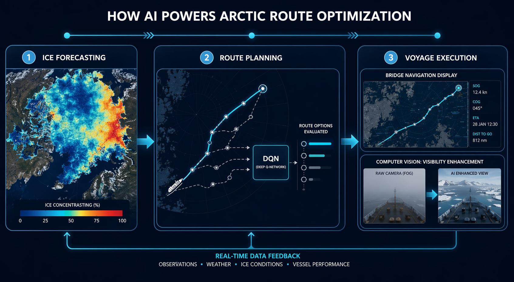
The first layer is short-range ice prediction. Johns Hopkins Applied Physics Laboratory reported a machine-learning model that predicts sea ice extent one to seven days ahead at 1 km resolution, with stated accuracy declining from 97% at one day to 93% at seven days.[5] That kind of forecast belongs close to the voyage desk. A seven-day view at kilometer scale can affect whether a ship holds a safer line, waits for an opening, accepts a longer deviation, or requests support before the schedule becomes unrecoverable.
The second layer is longer-range planning. IceNet, developed with the British Antarctic Survey and described in Nature Communications coverage, was reported to predict sea ice presence about two months ahead with roughly 95% accuracy while running thousands of times faster than physics-based models.[6] That does not make it directly comparable with the Johns Hopkins APL figure. The time horizon, target variable, and evaluation setup differ. Its value is earlier commercial screening: whether a vessel should be nominated for an Arctic attempt, whether the laycan has enough flexibility, and whether the expected savings justify preparing an alternative plan.
Only after those forecast layers does route optimization become useful. A route engine can generate alternatives across ice concentration, expected speed loss, fuel burn, emissions, distance, weather exposure, icebreaker coordination, and arrival windows. The better systems do not produce a single answer dressed up as certainty. They show the cost of choosing one risk over another.
Why DQN-style Routing Is a Better Fit Than a Shortest-Path Tool
Arctic routing is a poor environment for a simple shortest-path answer. A route that saves distance can increase ice exposure. A route that minimizes fuel may miss the delivery window. A route that reduces emissions may add time or require a less attractive ice corridor. That is why reinforcement-learning approaches, including deep Q-network models, are worth watching: they are designed to evaluate sequential decisions where the result of one routing choice changes the choices available later.
Li et al.’s 2026 Ocean Engineering study is useful because it reports the trade-off instead of pretending it disappears. In the study, a DQN balanced strategy produced 1.53% lower emissions than a cost-priority strategy, while accepting a 4.94% distance increase and a 3.79% time increase.[7] That is not a universal operating ratio. It is model-specific and recent enough that independent replication still matters. But the structure of the result is exactly what Arctic dispatch needs: an explicit exchange among distance, time, cost, and emissions.
This is where AI changes the commercial conversation. A planner can put three choices in front of a logistics executive and an insurer: the fastest route with higher ice exposure, the lowest-cost route with weaker emissions performance, and the balanced route that gives up some distance to avoid a riskier sector. The model does not make the sailing decision. It makes the consequence of the decision visible enough for the right people to own it.
The Evidence Ledger: What Each Claim Proves
The temptation is to stack every percentage into one optimistic paragraph. That is bad analysis. The numbers in Arctic AI routing describe different things: route economics, fleet-level savings, forecast skill, market growth, and model trade-offs. They should not be averaged, directly compared, or treated as interchangeable proof of commercial readiness.
| Evidence | What it supports | What it does not prove |
|---|---|---|
| ~21,000 km via Suez versus ~12,800 km via NSR; 10–15 day advantage | The NSR has a real distance and time premise for Asia-Europe trades when navigable | That any vessel can use the route economically or safely |
| AI weather routing fuel savings up to 17%; Orca AI reports 3–5% annual fuel savings and ROI within three months | Optimization can produce commercially meaningful fuel savings | That vendor-reported ROI will transfer to every Arctic fleet or voyage |
| JHU APL 1–7 day sea ice extent forecast at 1 km resolution, 97% to 93% stated accuracy | Short-range ice prediction is becoming operationally relevant | That forecast accuracy eliminates ice risk |
| IceNet roughly 95% two-month sea ice presence accuracy | Longer-range screening can improve seasonal and commercial planning | That its accuracy metric is directly comparable with short-range models |
| DQN balanced strategy: 1.53% emissions reduction with 4.94% distance and 3.79% time penalties | AI can make route trade-offs explicit across competing objectives | That those percentages are a general Arctic benchmark |
| HTF MI market projection and roughly 18% voyage-efficiency gain | There is commercial momentum around Arctic shipping routes | That market enthusiasm resolves operational constraints |
This sorting matters because an executive buying route optimization is not buying “accuracy.” They are buying fewer wasted nautical miles, fewer surprise ice encounters, better bunker planning, stronger evidence for insurance and charter-party discussions, and a more defensible go/no-go decision. A high forecast score is only valuable if it changes one of those outcomes.
Computer vision sits in the same category: useful, but easy to oversell. NTNU-linked work described by Maritime Executive focuses on AI image tools that can improve degraded images for autonomous or assisted navigation in Arctic conditions, where snow, fog, darkness, and low contrast can impair perception.[8] That is not the same as solving autonomous Arctic navigation. It is a supporting capability for one of the grittier problems on the bridge: seeing enough, soon enough, to confirm that the track the software recommends still matches the water in front of the ship.
From Dashboard Recommendation to Sailing Decision
The practical workflow is less tidy than most software diagrams. A planner may start with a two-month ice outlook, compare candidate departure windows, and reject some cargoes before any route is drawn. A week before departure, the short-range ice model may narrow the corridor or show that a previously attractive option now carries too much delay risk. The optimization engine then scores routes against fuel, time, emissions, ice concentration, and support constraints. The master and shoreside team review the plan. During the voyage, new imagery, satellite updates, weather forecasts, and observed conditions force revisions.
- Long-range screening: decide whether the NSR is commercially plausible for the vessel, cargo, and season.
- Pre-voyage routing: generate alternatives that reflect ice, weather, speed, fuel, emissions, and support assumptions.
- Trade-off selection: choose a route with explicit penalties and benefits rather than a single optimized answer.
- Bridge execution: use updated forecasts, image enhancement, radar, human observation, and company rules to validate the plan.
- In-voyage adjustment: revise the track when ice motion, weather, communications, or support availability changes.
The operators most likely to benefit are not general open-water fleets hoping to shave days from a conventional schedule. They are operators with vessels built or certified for the environment, cargoes that reward shorter Asia-Europe transit, and organizations that can handle the administrative and operational load of Arctic passage. The AI layer improves the commercial envelope; it does not change the steel in the hull.
That distinction is visible in actual NSR activity. ORF reported 37.9 million tonnes of cargo and 92 full NSR transits in 2024.[9] Those figures show a functioning corridor, not a mass substitution for Suez. The question for 2026 is therefore not whether every Asia-Europe ship should be routed north. It is whether the right ships can be scheduled with enough confidence to make the NSR part of a controlled network option rather than a one-off exception.
Vendor Tools Are Signals, Not Settlements
The vendor landscape is moving in the expected direction. Orca AI is associated with route optimization and navigation intelligence. Sofar Ocean’s Wayfinder, Sinay, Kongsberg Maritime, Nautilus Labs/Danelec, Windward, and JUSDA’s JusLink all sit around parts of the voyage planning, maritime intelligence, emissions, risk, and supply-chain visibility problem. Their existence matters because adoption usually follows tool availability, integration, and user trust. But vendor disclosure is not the same as independent evidence.
JUSDA’s Arctic corridor material is a useful example of the care needed. Its claim of 80% to 90% emissions reduction versus Suez is best read as a limited comparison of a favorable Arctic summer case against an unfavorable Suez benchmark, not as a typical NSR outcome.[10] A logistics executive should not put that number into a board deck without the assumptions beside it. More credible emissions planning comes from comparing specific vessel classes, loads, speeds, ice conditions, fuel types, and route alternatives.
The useful buyer’s question is not which platform has the boldest Arctic claim. It is whether the system can show its inputs, preserve alternative routes, update assumptions during the voyage, export an auditable decision record, and degrade gracefully when data quality falls. In Arctic routing, a beautiful dashboard that hides uncertainty is worse than a conservative tool that makes uncertainty operational.
Where the Boundary Still Sits
The same models that make the NSR more schedulable also show why it is not a universal Suez replacement. The limiting factors are not only climatic. Satellite connectivity can be uneven at high latitudes. Ground-truth data for training and validation remain sparse compared with dense temperate shipping lanes. Ice forecasts still carry uncertainty, especially when wind and current move ice faster than a plan can absorb. Russian jurisdiction over the NSR adds political and administrative exposure. Icebreaker dependence and insurance premiums can consume part of the distance advantage.
The vessel-class boundary is especially important. Nature Communications Earth & Environment research projects that PC7 ships could reach 301 navigable days per year by 2100 under SSP2-4.5, up from 199 in 2023.[11] That is a long-horizon projection, not a 2026 operating guarantee. It also points in the right direction for ice-capable vessels, not for ordinary open-water ships.
The same study reports a severe effect from sea ice motion on open-water vessel navigability, with navigable grid proportion falling from 70.33% to effectively 0.01% when sea ice motion is considered.[11] That caveat should be pinned to every optimistic Arctic routing presentation. Static ice concentration is not enough. Ice moves. A corridor that looks passable in a simplified planning layer can become commercially irrelevant for a vessel that cannot tolerate the actual motion, pressure, or closing speed of ice fields.
Connectivity and data coverage also affect the practical value of in-voyage AI. A model may generate a better route on shore than the ship can reliably refresh at sea. If satellite bandwidth is constrained, the operating plan needs rules for stale forecasts, delayed imagery, and fallback routing. The master cannot wait for a cloud service to confirm what the hull, radar, and lookout are already telling the bridge.
What Commercial Viability Means in 2026
Commercial viability does not mean the NSR replaces Suez year-round for general container traffic. It means that, for selected vessel classes and cargo profiles, AI can reduce enough planning uncertainty to make the Arctic route a defensible option. The strongest case is for ice-class or polar-capable vessels, higher-value or time-sensitive cargoes, operators with Arctic procedures already in place, and voyages where a 10 to 15 day time advantage has real commercial value rather than cosmetic appeal.[1]
The decision should be made with a narrow scorecard. First, confirm the vessel’s suitability, not just the route’s theoretical availability. Second, test the cargo against delay and diversion scenarios. Third, compare fuel and emissions outcomes under realistic speed and ice assumptions. Fourth, price insurance, escort, administrative, and communications costs into the voyage economics. Fifth, require the AI system to preserve uncertainty, alternatives, and decision history rather than returning a single clean line.
That is less exciting than saying AI has opened the Arctic. It is also closer to how ships are dispatched. AI has moved Arctic routing from speculative frontier toward an emerging logistics option: measurable fuel savings, stronger ice forecasting, better route trade-offs, and more disciplined in-voyage adjustment. In 2026, its realistic value is selective deployment on appropriate vessels and lanes, not a general year-round replacement for Suez.
References
- Polar Shipping Routes, Geography of Transport Systems.
- News from the Arctic (2024.04), WWF Arctic, 2024.
- From Voyage Planning to Maritime Route Optimization, Orca AI.
- Arctic Shipping Routes Market Analysis, HTF Market Intelligence, 2026.
- New AI Promises Ships Safer Passage Through Arctic Seas, Johns Hopkins APL, 2023.
- On Thin Ice: Arctic AI Model Predicts Sea Ice Loss, NVIDIA / British Antarctic Survey.
- Intelligent Arctic shipping route planning with dual objectives…, Li et al., Ocean Engineering, 2026.
- AI Image Tools May Help Autonomous Ships Drive Safely in the Arctic, Maritime Executive / NTNU, 2024.
- Understanding the potential of the Northern Sea Route, ORF Online, 2024.
- Arctic North Sea Route Reshapes Global Supply Chains, JUSDA, 2025.
- Ships projected to navigate whole year-round in the Arctic Ocean by the end of the twenty-first century, Zhao, Li & Zhang, Nature Communications Earth & Environment, 2024.
Comments
Join the discussion with an anonymous comment.