
AI flood prediction becomes useful to supply chain teams at the point where it stops answering “will there be flooding?” and starts answering “which supplier, lane, warehouse, or port decision has to move before the water arrives?” That is the gap many climate-risk dashboards still leave open. A red polygon around a supplier site may be enough for annual risk scoring. It is not enough when procurement needs to know whether to qualify an alternate source, logistics needs a reroute window, and finance wants to understand whether the mitigation spend is defensible.
The market in 2026 is far enough along to evaluate, but not uniform enough to buy generically. Some AI systems forecast river levels several days ahead. Some estimate building-level flood depths for coastal storms. Some detect floodwater after an event using satellite radar. Some simulate how long a disrupted network may take to recover. Calling all of them “AI flood prediction” hides the most important procurement question: what decision will this output actually support?
The urgency is not theoretical. Everstream Analytics reported that flooding caused 70% of weather-related supply chain disruptions in 2024 and ranked flooding as the top supply chain threat for 2025, according to Bloomberg coverage of the firm’s forecast.[1] SupplyChainBrain, citing Everstream’s 2025 Annual Risk Report, reported 123 U.S. flooding events in 2024 alone.[2] Those figures do not prove that every network needs the same tool. They do explain why static flood-zone overlays are no longer a sufficient answer for supplier risk teams.
The Four AI Flood Capabilities Buyers Should Separate
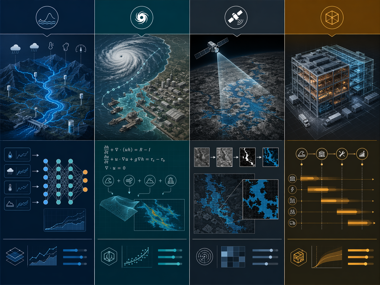
A useful evaluation starts by separating four technical approaches that often get blended together in vendor conversations. They are not interchangeable, and their accuracy claims should not be compared as if they were scored on the same test. A river forecast measured against stream gauges, a satellite flood mask measured by image classification accuracy, and a recovery-time model evaluated by error reduction are answering different questions.
| Approach | What it is best positioned to answer | Operational fit for supply chains |
|---|---|---|
| LSTM hydrologic forecasting | Which rivers are likely to flood, and with what lead time? | Supplier and logistics exposure in riverine regions, especially where gauge infrastructure is limited |
| Physics-informed and generative AI | How deep could floodwater be at a specific coastal or urban asset before landfall? | Building-level planning for coastal suppliers, ports, warehouses, and single-site dependencies as the approach matures |
| SAR computer vision flood mapping | Where is floodwater visible after or during an event, including through cloud cover? | Rapid damage assessment, access validation, and post-event network triage |
| Digital twins with recovery prediction | How might disruption propagate, and how long could service restoration take? | Scenario planning, inventory positioning, alternate routing, and recovery-time estimation |
LSTM Hydrologic Forecasting: The Practical Starting Point for Riverine Supplier Risk
Long short-term memory models are a natural fit for river forecasting because they are built to learn patterns across time-series data. Google Research’s 2024 Nature paper trained models on 5,680 streamflow gauges from the Global Runoff Data Center and reported that AI extended reliable flood predictions from zero-day nowcasts to five-day lead times, with five-day forecasts reaching reliability comparable to existing nowcasts.[3]
For supply chain risk teams, the important word is not “AI”; it is “lead time.” A five-day riverine warning can change a logistics plan. It can move inbound freight forward, delay noncritical shipments, pre-position inventory, or trigger calls to alternate carriers before a road closure becomes a customer-service issue. It also gives procurement enough time to check whether a flagged supplier is a single point of dependency or one of several qualified sources.
Google says Flood Hub now provides forecasts in more than 80 countries and serves more than 2 billion people.[4] That matters for tier-N monitoring because many supplier networks extend into regions where local gauge coverage is thin. The model does not erase regional variation or solve every flood type. Riverine flooding in a basin is not the same as pluvial flooding around an industrial park or storm surge at a coastal port. Still, among the approaches available today, LSTM-based hydrologic forecasting is one of the clearest candidates for broad supplier-location screening and early warning.
Physics-Informed and Generative AI: Building-Level Promise, Not Yet a Generic Purchase
Building-level flood prediction is the phrase most likely to catch a procurement committee’s attention, and also the phrase most likely to be misread. Georgia Tech reported in June 2026 that researchers coupled physical surge and rainfall simulations with generative AI to predict building-level flood depths three to five days before hurricane landfall. The same report said the approach achieved more than 90% accuracy for Hurricane Sandy-type events.[5]
That is a serious planning horizon for coastal assets. If a company has a port-adjacent warehouse, a coastal supplier, or a medical-materials facility that cannot be substituted quickly, flood depth is more actionable than a broad exposure score. A shallow-access problem may call for a carrier change. A deeper inundation estimate may call for inventory transfer, temporary supplier substitution, or a customer-allocation decision.
The caveat is just as important as the result. The Georgia Tech work should not be treated as an off-the-shelf supply chain platform simply because it reports building-level accuracy. The research brief supports a narrower conclusion: physics-informed and generative AI are pushing coastal and compound flood forecasting toward asset-level decisions, but buyers should verify where the model has operated, which storm types it has tested, and whether the output can be delivered inside the company’s decision window.
ECMWF’s AI Milestone Matters Because It Moves AI Into Operational Forecasting
Not every useful AI flood capability has to come from a commercial supply chain vendor. ECMWF reported that its Artificial Intelligence Forecasting System became the first operational AI integration in global flood forecasting systems when it was integrated into EFAS and GloFAS on September 10, 2025.[6] For risk teams, that milestone matters less as a shopping-list item than as evidence that AI is entering operational flood forecasting infrastructure, not just research demonstrations.
The procurement implication is straightforward: if a vendor says it uses AI flood forecasting, ask whether it is producing original forecasts, consuming operational forecast feeds, enriching them with supplier and lane data, or simply translating flood-hazard layers into risk scores. All four can be useful. They should not be priced, integrated, or governed as the same capability.
SAR Computer Vision: Detection and Mapping, Not Pre-Event Substitution
Synthetic aperture radar is valuable because it can observe floodwater through cloud cover, which is exactly when optical imagery often fails. RSS-Hydro’s FloodSENS work used U-Net and ResNet architectures on NVIDIA GPUs and reported 0.98 to 0.99 accuracy for detecting floodwater in SAR imagery.[7] NVIDIA’s coverage of the work said the approach reduced flood mapping time by up to 80% compared with manual methods.[8]
That accuracy is impressive, but it is not the same thing as a five-day forecast. SAR computer vision is strongest when the network needs to know what is already inundated, which access roads are likely unusable, or whether a supplier’s surrounding area has been affected. It is especially relevant to control towers, claims teams, logistics coordinators, and crisis cells that need fast geospatial confirmation after a storm.
A buyer who needs pre-event supplier substitution should not treat a flood-detection product as a prediction engine. A buyer who needs post-event triage should not dismiss it because it does not predict landfall impacts. The question is whether the decision is “act before water arrives” or “prioritize response after water is visible.”
Digital Twins: Recovery Time May Be More Useful Than Flood Depth
Supply chains do not recover the moment a flood recedes. A plant may be dry while inbound roads remain closed. A supplier may reopen while upstream components are still delayed. A warehouse may be accessible but short of labor, power, or outbound capacity. This is where digital twins and recovery models belong in the flood prediction discussion.
A 2025 Supply Chain Analytics study reported an LSTM flood-prediction model with 73% recall, 75% accuracy, and 84% AUC-ROC, and also described multilayer neural networks used to predict recovery timelines with consistent mean-squared-error reduction.[9] Those metrics are not directly comparable with SAR detection accuracy or Google’s hydrologic forecast reliability. They are aimed at a different planning problem: how a disruption affects network performance over time.
The World Meteorological Organization has described South Korea’s operational flood forecasting system across 223 locations, using LSTM updates at 10-minute intervals, with digital twin integration expected in 2026.[10] The combination is important. Frequent forecasting can support immediate warning, while a digital twin can help translate that warning into expected service loss, recovery sequence, and bottleneck exposure.
For a network planner, “supplier site likely inundated” may be only the first question. The next question is whether the disruption causes a one-day lane delay, a week-long regional capacity problem, or a cascading shortage because the site feeds multiple downstream plants. Digital twins are useful when they preserve that dependency logic instead of reducing the event to a single red dot on a map.
How Flood Forecasts Enter Sourcing and Logistics Workflows
The practical test for AI flood prediction in supply chain resilience is whether the forecast changes a workflow before the disruption becomes expensive. That means the tool has to sit close enough to supplier master data, lane data, inventory positions, and control-tower escalation rules to trigger an action. A technically strong forecast that arrives as a separate map layer may still fail if nobody can connect it to purchase orders, alternate carriers, customer commitments, or tier-N dependencies.
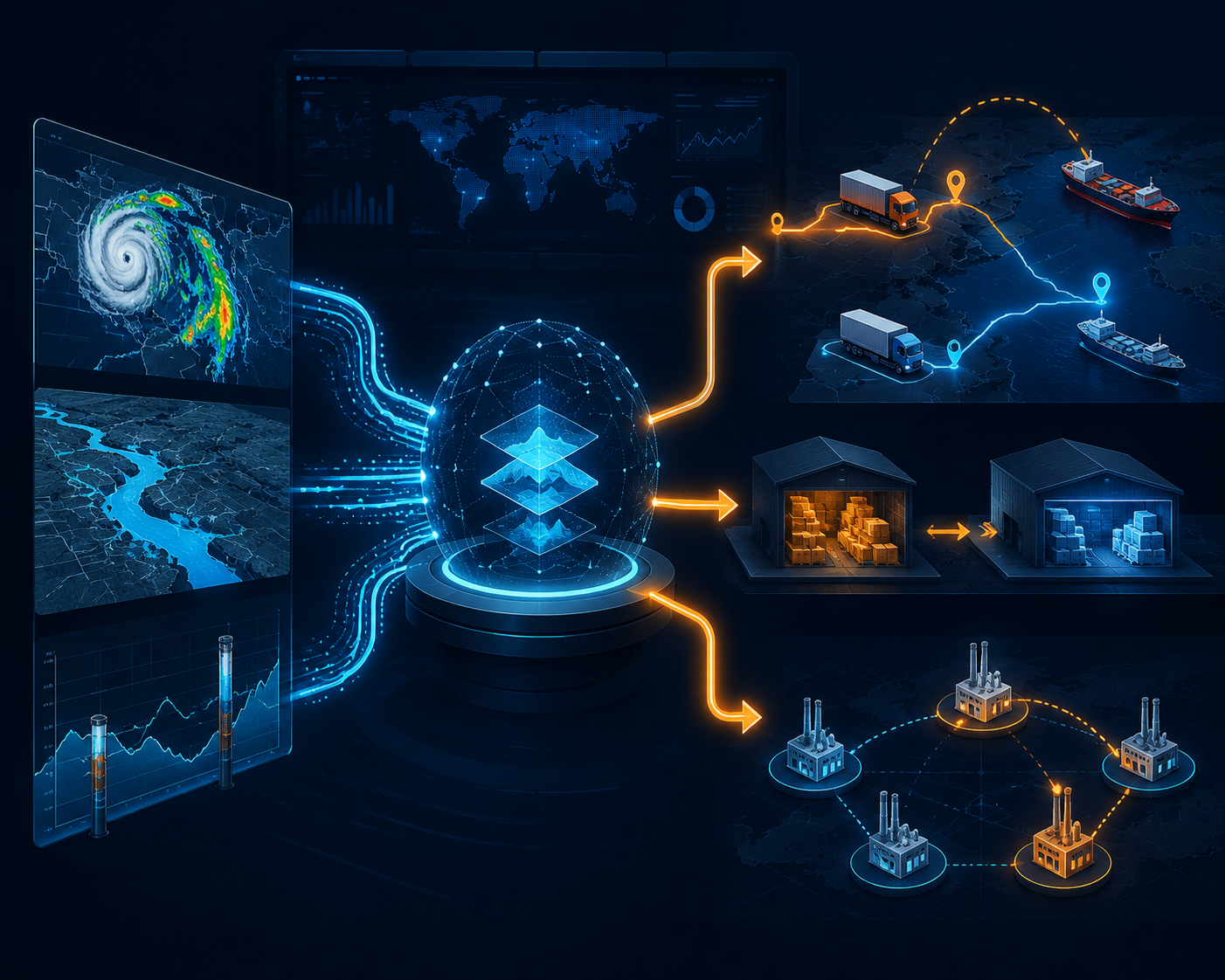
A five-day river forecast has value only if the company has already defined what happens at day five, day three, and day one. At day five, a risk team might flag exposed tier-one and tier-two suppliers and check open orders. At day three, logistics may reserve alternate capacity or shift origin and destination plans. At day one, operations may stop pretending the event is only a weather alert and move into allocation, customer communication, or production resequencing.
The same logic applies to geography. A global manufacturer sourcing from river basins across South Asia, Latin America, and parts of Africa may care first about broad country coverage and ungauged-basin performance. A company with coastal distribution centers may care more about compound flood modeling and asset-level depth estimates. A retailer with thousands of stores may value rapid satellite confirmation after landfall because store status, road access, and replenishment timing change by neighborhood.
Internal links between flood forecasts and disruption playbooks are often where the business value appears. Teams building broader response processes can connect these outputs to AI supply chain flood risk management practices, or to flood disruption planning workflows that define when inventory, sourcing, and transportation decisions move from monitoring to execution.
What to Ask Before Shortlisting a Platform
Vendor selection should start with the decision category, not the model label. Google Flood Hub is a useful example of broad LSTM-based river forecasting. ECMWF’s AIFS shows AI entering operational global flood forecasting infrastructure. RSS-Hydro FloodSENS is closer to rapid flood mapping and post-event assessment. Everstream Analytics is better understood as a supply chain risk analytics platform that can contextualize flood threats against supplier and logistics exposure. One Concern fits the resilience-platform category, where the value depends on how hazard data, asset data, and recovery assumptions are modeled together.
- Coverage: Does the tool cover the countries, basins, ports, warehouses, and supplier tiers that actually matter to the network?
- Flood type: Is it forecasting riverine flooding, coastal surge, pluvial flooding, or detecting flood extent after the event?
- Lead time: Does the warning arrive early enough for rerouting, inventory positioning, supplier substitution, or only post-event assessment?
- Resolution: Is “building-level” based on asset-specific depth estimates, satellite flood masks, parcel exposure, or a modeled digital twin?
- Metric: Is accuracy measured as forecast reliability, classification accuracy, recall, AUC-ROC, F1 score, or recovery-time error?
- Integration: Can alerts connect to supplier records, lane plans, control-tower queues, and escalation rules without manual map interpretation?
The metric question deserves extra attention. A 0.99 floodwater-detection accuracy claim does not mean a supplier outage will be predicted with 99% accuracy. A 75% model accuracy in a digital-twin study does not mean the platform is weak if the harder problem is recovery timing across a network. A more disciplined comparison asks whether the metric matches the operational decision and whether the model has been tested in geographies similar to the company’s footprint.
ROI benchmarks can help justify attention, but they should not carry the business case alone. The Climate Drive, citing World Bank research, states that early warning systems can reduce flood-related economic costs by 35% to 50%.[11] That is directionally useful, but the research brief does not verify the underlying study methodology. A stronger business case starts from the actions made possible: earlier carrier booking, avoided premium freight, faster supplier checks, better allocation decisions, and fewer hours spent reconciling maps with order data.
A Practical Match Between Method and Network
The right answer is rarely one model across the entire enterprise. A network with riverine sourcing exposure may start with LSTM-based forecasting because coverage and lead time are the main constraints. Coastal assets and hurricane-exposed facilities may justify watching physics-informed, building-level methods closely, while verifying commercial readiness and integration. A control tower responsible for post-event visibility may need SAR computer vision more than another pre-event score. A network design team may get more value from digital twin recovery simulation than from an additional flood-depth layer.
This is also where tier-N supplier monitoring becomes more than a data-enrichment project. If the company only maps tier-one sites, a five-day basin forecast may miss the upstream component supplier that will stop production two weeks later. If the company maps tiers but has no approved substitution logic, an alert becomes a notification rather than a decision. Flood prediction is most useful when it is paired with the operational rights to act.
For teams comparing AI disruption-planning investments beyond floods, the same evaluation discipline applies: define the decision, identify the required lead time, test the geographic coverage, and ask how the output enters execution. That broader investment framing belongs with AI disruption planning capabilities rather than with a single hazard model.
AI flood prediction is ready for supply chain risk teams to evaluate in 2026. The buying question is no longer whether the model looks impressive. It is whether the lead time, spatial resolution, metric, data dependency, and geographic coverage fit the supplier and logistics network. Confuse prediction with detection, risk scoring, or recovery simulation, and the company may buy a tool that is technically advanced but operationally late.
References
- Floods Are Top Risk to Supply Chains in 2025, Everstream Says, Bloomberg, January 2025.
- Report: Floods Pose Top Threat to Supply Chains in 2025, SupplyChainBrain.
- Global prediction of extreme floods in ungauged watersheds, Nature, 2024.
- Using AI to expand global access to reliable flood forecasts, Google Research.
- How AI-Powered Flood Forecasts Could Transform Hurricane Resilience, Georgia Tech, June 30, 2026.
- AI takes CEMS flood forecasting into a new era, ECMWF.
- FloodSENS: a deep learning-based floodwater segmentation tool for synthetic aperture radar imagery, npj Climate and Atmospheric Science, 2023.
- Strengthening Climate Resilience with AI-Powered Flood Modeling and 3D Visualizations, NVIDIA Developer Blog.
- A digital twin framework for flood resilience in supply chains, Supply Chain Analytics, 2025.
- Future of flood forecasting: technology-driven resilience, World Meteorological Organization.
- Advanced flood resilience through AI forecasting, The Climate Drive.
Comments
Join the discussion with an anonymous comment.