
The useful moment for AI hurricane forecasting for supply chain logistics is not when a storm has made landfall. By then, the freight market is already reacting: carriers are protecting equipment, receivers are changing dock plans, terminals are watching cutoffs, and every shipper with exposed freight is trying to buy the same safer lane at the same time.
It comes earlier, when the storm is still a probability on a map but the exposed purchase orders, carrier schedules, facility coordinates, port calls, and customer promises are already real. Everstream Analytics, as reported by Forbes, disseminates gridded weather data 15 days in advance on an hourly basis for any global coordinate, supported by a team of five meteorologists.[1] That kind of input does not move freight by itself. It becomes valuable only when a logistics team can connect it to the network decisions that will be expensive to change later.
Hurricane Ian is the reminder not to confuse forecast visibility with operational safety. In September 2022, shipments across affected regions fell by 75%, and shipping times increased by 2.5 days, according to Forbes reporting that cited Everstream data.[1] The storm was not invisible. The logistics shock still arrived.
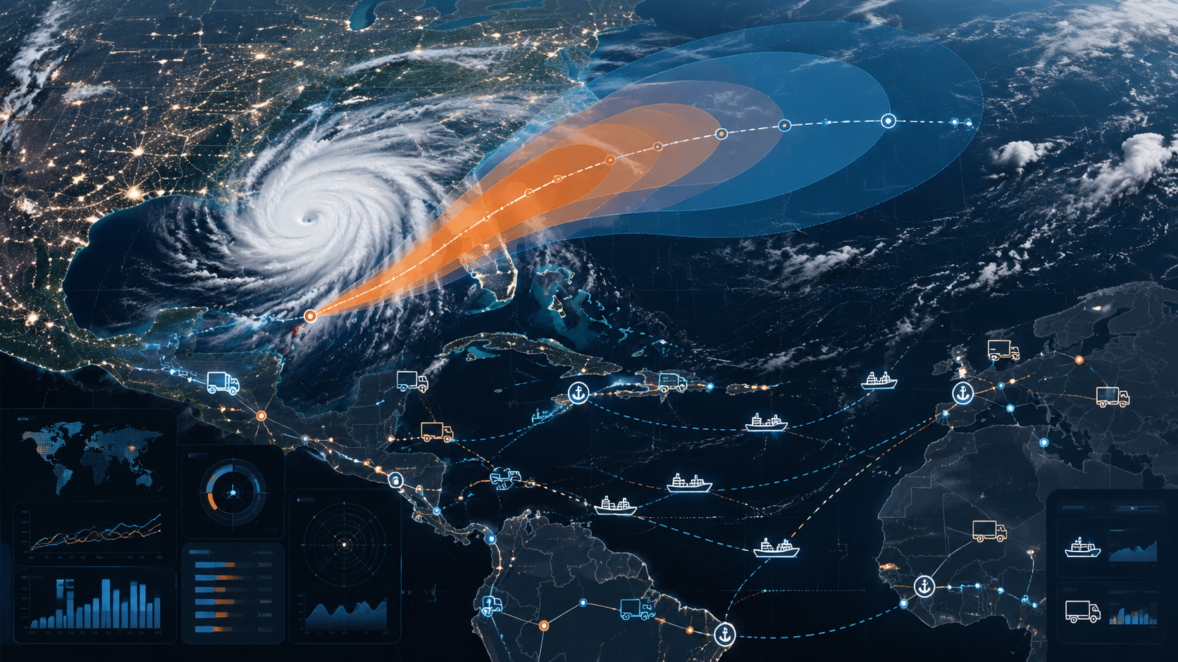
That is the practical test for AI hurricane forecasting in route optimization. The question is not whether a model can make the storm look more legible in a dashboard. The question is whether the warning arrives early enough, and with enough supply chain context, for someone to reroute freight, change mode, reserve capacity, hold product intentionally, or send a customer ETA update before the decision has been taken away by congestion and price.
The forecast has to meet the freight, not sit beside it
A hurricane forecast becomes a logistics tool only after it is joined to the shape of the supply chain. A cone over the Gulf or Atlantic is useful context. A probabilistic impact forecast tied to supplier coordinates, plant gates, port terminals, rail ramps, cross-docks, carrier schedules, in-transit loads, and customer delivery windows is where transportation planning starts.
The work starts with location precision. A logistics team needs to know which assets sit inside or near the forecast risk area, and not just by city name. A supplier outside the worst wind field may still depend on a flooded approach road. A port that avoids a direct hit may still change gate hours or vessel schedules. A carrier pickup that looks safe on Monday may become unusable if the delivery appointment is on the wrong side of the storm path two days later.
Coordinate-level weather feeds matter because supply chains are built from coordinates. The relevant objects are not abstract regions; they are origin docks, destination docks, highway segments, ports, ramps, yards, distribution centers, and vehicles already moving between them. Hourly, 15-day gridded data gives the planning team a time series they can compare against pickup windows, sailing schedules, appointment calendars, and promised delivery dates.[1]
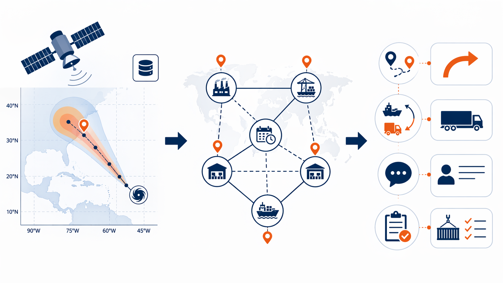
That fusion is where AI earns its keep. The platform is not merely displaying weather; it is scoring exposure across a network topology. A shipment from a supplier to a DC may be evaluated against the origin, planned highway path, destination, nearby transload options, carrier availability, and the time at which each point is likely to face disruption. A planner does not need a prettier map as much as a ranked set of loads, lanes, and facilities that deserve attention while there is still room to maneuver.
| Forecast input | Supply chain data it must touch | Decision it can support |
|---|---|---|
| Hourly gridded forecast at coordinates | Supplier, plant, port, warehouse, and customer locations | Which sites need earlier dock, labor, or inventory decisions |
| Probable storm timing and severity by location | Pickup appointments, delivery windows, sailing schedules, and transit plans | Which shipments can still depart, which should wait, and which need a different path |
| Route-level disruption scoring | In-transit loads, planned lanes, carrier capacity, and alternate corridors | Whether to reroute, split freight, pre-book capacity, or change mode |
| Impact confidence and uncertainty bands | Customer commitments, service rules, and escalation thresholds | When to send ETA updates and when to require human approval |
Lead time is the economic unit
Transportation teams do not need perfect certainty to make a better decision. They need usable lead time. If a route is likely to close, a port is likely to suspend operations, or a receiver is likely to lose appointment integrity, the valuable hours are the ones before carriers and alternative modes are fully repriced by the rest of the market.
The road network alone makes that timing problem visible. Everstream states that weather is responsible for 23% of all U.S. road delays and estimates the cost to the trucking industry at $2 billion to $3.5 billion annually through shift disruptions, holding costs, late fees, and customer retention losses.[2] Those are not abstract resilience costs. They show up as detention arguments, missed retail windows, premium freight approvals, overtime at the dock, and the uncomfortable email explaining why a shipment that looked recoverable yesterday no longer is.
This is why route optimization during hurricane season should be judged less by a generic accuracy claim and more by what the forecast changes on Tuesday for a shipment that would otherwise fail on Friday. A useful system pulls forward the decision point. It gives transportation enough time to ask whether a load should leave early, move inland, switch to rail before a ramp cutoff, avoid a coastal corridor, consolidate with other freight, or wait at origin instead of becoming stranded in the middle of the network.
From impact score to action
The clean version of the workflow is simple: ingest the forecast, match it to assets and lanes, score the operational impact, then recommend actions. The working version is messier because each action has a cost, a service consequence, and a point of no return.
- Rerouting: move freight away from a corridor, terminal, or delivery region before closures, congestion, or carrier refusals narrow the available options.
- Mode shift: change from truckload to intermodal, air, ocean, rail, or a multimodal plan when the normal mode no longer protects the delivery promise.
- Capacity reservation: secure alternative carriers, trailers, chassis, drayage, or cross-dock capacity before the local market prices in the storm.
- ETA communication: give customers a conditional update while there is still credibility in the plan, not after the appointment has already failed.
- Intentional hold: keep freight at a safer origin or upstream node rather than allowing it to drift into a disrupted lane because the original plan was never revisited.
The best systems make those options visible in operational language. A planner should be able to see that three loads bound for a coastal DC are exposed during the delivery window, that two can depart earlier without breaking production release rules, that one should be held, and that an alternate inland cross-dock has capacity if the customer accepts a later final-mile handoff. The model may help prioritize the work, but the decision still has to pass through transportation reality: contractual carrier commitments, product criticality, customer penalties, labor availability, and inventory position.
Vendor categories are useful here as examples of different parts of the stack, not as a league table. Everstream is relevant for meteorologist-supported weather intelligence and logistics disruption scoring, including the 15-day hourly coordinate-level capability reported by Forbes.[1] ClimateAi is closer to the impact-translation layer, where probabilistic weather signals are connected to business exposure. The Weather Company frames weather risk for enterprise leaders; its Weather Means Business report found that 90% of executives say weather impacts operations and 92% plan to increase their use of weather insights.[3] SEKO’s AI freight forecasting belongs nearer the routing and multimodal planning problem, where the question is how to move cargo when the original plan is losing feasibility.
Those distinctions matter because a hurricane workflow can fail at several points. A strong meteorological signal is not enough if it never touches shipment data. A good lane risk score is not enough if no one can book the alternative capacity. A routing recommendation is not enough if it ignores a customer’s receiving hours or a carrier’s equipment position. The useful product is the chain of translation from forecast to exposed asset to ranked operational decision.
A warning signal is not a route instruction
Probabilistic forecasting should give operations teams permission to act before certainty arrives. It should not quietly convert uncertainty into automated freight moves without review.
That boundary is especially important in hurricane planning because the expensive decision is often made before the forecast has settled. If the system shows a high probability that a port, ramp, or delivery region will be disrupted in five to seven days, a planner may need to reserve capacity or change a route now. But the confidence level, exposure window, freight value, customer tolerance, and reversibility of the action all matter. A model can rank the decision. It should not bury the reason.
A responsible workflow preserves the human-in-the-loop step where the risk becomes a logistics action. That review does not need to be slow. It can be a rules-based escalation: low-cost ETA alerts may send automatically; moderate-risk loads may move to a planner queue; high-cost reroutes, mode changes, or customer-impacting holds may require approval from transportation leadership or the account owner. The point is to document who accepted the risk, what alternatives were considered, and why the team acted before the storm outcome was certain.
Unsupported accuracy claims should stay out of the decision file. One secondary source attributes an 85% major-disruption identification rate and an average seven-day lead time to AI-driven platforms in a Johnson & Johnson deployment, but the primary Johnson & Johnson source was not confirmed in the available materials.[4] That figure may be worth verifying editorially. It should not be treated as operational evidence until it is tied to a primary disclosure, a defined sample, and a clear explanation of what counted as a detected disruption.
The same caution applies to model performance language more broadly. Adoption is not effectiveness. A dashboard view is not a routing outcome. A forecast hit is not a recovered delivery. For logistics route optimization, the better metric is operational lead time: how many hours or days earlier the team identified exposed freight, secured a feasible alternative, and communicated the new plan.
What has to be connected before hurricane season
A hurricane workflow cannot be assembled from scratch once the forecast cone is already sitting on top of the network. The data connections need to exist before the first serious watchlist forms.
- Asset coordinates: suppliers, plants, ports, ramps, yards, warehouses, cross-docks, customer ship-to points, and critical road or drayage corridors.
- Shipment status: planned, tendered, accepted, in transit, at risk of missing appointment, or eligible for early release.
- Carrier and mode options: contracted carriers, spot alternatives, rail and intermodal feasibility, drayage capacity, and time-sensitive air options.
- Service rules: customer delivery windows, chargeback exposure, product criticality, temperature or handling constraints, and escalation owners.
- Decision thresholds: which forecast probabilities trigger monitoring, planner review, customer notice, capacity reservation, or executive approval.
That last item is often where the gap shows. Many teams can see a storm coming. Fewer have agreed in advance what probability and lead time justify booking extra capacity, changing a delivery promise, or holding freight at origin. Without those thresholds, the forecast becomes a meeting topic instead of a planning input.
The thresholds do not have to be identical for every shipment. A low-margin replenishment load may tolerate a wait-and-see posture. A production-critical inbound component may justify an early premium move. A retail promotion with a fixed launch date may need customer communication as soon as the delivery window becomes conditional. AI hurricane forecasting helps most when it exposes those differences early enough for the planner to choose deliberately.
Seasonal outlooks do not remove the single-storm problem
A quieter seasonal forecast can be useful background for staffing and broad readiness, but it does not change the route optimization problem. One landfalling storm in the wrong corridor is enough to close a port, distort truck capacity, disrupt appointments, and force premium decisions. The economics of Hurricane Ian make that point without needing a historically extreme season.[1]
The available evidence here is strongest for U.S. Atlantic and Gulf logistics exposure, because the cited road-delay and Hurricane Ian data are U.S.-centered.[1][2] The same planning logic can apply to Pacific typhoons and Indian Ocean cyclones, but local network data, carrier practices, port procedures, and forecast sources determine whether the model output becomes a usable logistics decision.
Demand surge prediction and supplier risk mapping sit nearby, but they are different questions. A storm may change consumer demand, factory output, or raw-material availability. This use case is narrower: protecting route, mode, capacity, and ETA decisions for freight already exposed to the path or likely to be assigned into it.
A practical definition of success
AI hurricane forecasting succeeds in logistics when it changes decisions early enough to matter. The output should not be judged by whether it sounds confident. It should be judged by whether it gives transportation teams better-conditioned choices before the market tightens.
That means fewer last-minute expedites because high-risk loads were identified before the miss became unavoidable. It means earlier rerouting and mode decisions because the system connected weather timing to shipment timing. It means clearer ETA communication because customer-facing teams had a conditional plan instead of a surprise. And it means a documented human decision process for acting on probabilistic hurricane risk, so the organization can see why freight moved, waited, or changed mode before certainty arrived.
References
- Effectively Using Weather Forecasts Is A Supply Chain Imperative, Forbes, September 2025
- Weather-Proof Your Logistics Operations, Everstream Analytics
- Weather Means Business, The Weather Company
- AI-driven platforms identify 85% of major supply disruptions an average of seven days before impacts materialize, World Certification Institute
Comments
Join the discussion with an anonymous comment.