§ 41 — Use-case analysis
Can AI Planning Platforms Handle Charlotte's Flooding Road Closures?
This analysis examines whether AI-driven planning platforms can effectively mitigate the recurrent flooding and road-closure disruptions that threaten Charlotte's logistics corridor. It finds a critical evidence gap: while platform capabilities map to the use case, no vendor has published a named, dated post-mortem of a Charlotte flood event, forcing buyers to assess generalized ROI claims without local validation.
After the water drops, the platform question gets much less abstract. A planning director is not asking whether AI can “improve resilience” in a deck. She is asking whether, before Tropical Storm Debby closed roads around Charlotte, before Hurricane Helene exposed regional supply-chain fragility, or before another round of flooding shut down local routes, an AI planning system would have changed a dispatch decision, a dock schedule, a carrier call, or a customer promise.
That is the right test for AI disruption planning around Charlotte’s flood-related road closures. The use case is not generic disruption management. It is a dense operating corridor where a few blocked links can turn into missed delivery windows, detention exposure, re-sequenced appointments, and service explanations that customer teams have to deliver with very little warning.
Charlotte’s flood exposure is real, though the cleanest published flood-risk figure has a narrow boundary: First Street Foundation identifies 13,921 properties, or 5.1% of properties, at flood risk in Charlotte city proper, not the full metro logistics footprint.[1] The logistics footprint is broader and operationally heavier. The Charlotte region’s logistics and distribution profile cites 89,000 logistics-sector employees, 35,000 truck drivers, four interstate corridors—I-85, I-77, I-40, and I-485—and 100 million consumers within one-day trucking distance.[2]
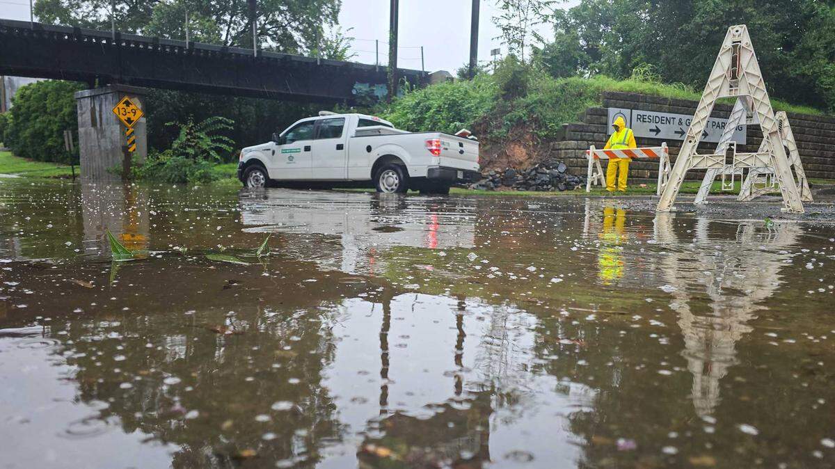
The recent event history is not a theoretical climate slide. Tropical Storm Debby brought road closures throughout the Charlotte region in August 2024, including sections involving I-85 and I-77.[3] Hurricane Helene, the next month, exposed supply-chain vulnerabilities across North Carolina and showed how regional manufacturing and logistics networks can be strained when transportation, power, and supplier continuity fail together.[4] In August 2025, flooding again closed multiple roads throughout the Charlotte region.[5]
Those events do not prove that a specific AI platform would have prevented losses. They do establish the buyer’s problem: Charlotte-area logistics teams face recurring flood-driven road-closure disruptions in a corridor whose value depends on reliable regional reach.
What An AI Planning Platform Would Have To Change
For this use case, the platform earns its keep only if it changes decisions while time still matters. A useful system would detect likely closures early enough to protect appointment schedules, compare reroute options against fuel and driver-hour constraints, identify which orders will miss promise dates, and reconcile the new transportation plan with inventory, production, and customer commitments.
The national economics explain why the issue is getting attention at the budget table. Everstream Analytics has reported that weather causes 23% of all U.S. road delays and costs trucking $2 billion to $3.5 billion annually.[6] Public reporting on Everstream’s 2025 risk work says flooding accounts for 70% of weather-related supply-chain disruptions globally.[7] Everstream’s 2026 outlook also says extreme weather events have accelerated from once every four months to once every three weeks.[8] Those figures are not Charlotte-specific, and two of the broader risk statistics rely on publicly accessible summaries rather than a fully open underlying report. They still point in the same operational direction: weather-related transportation disruption is frequent enough that manual exception handling is no longer a satisfactory planning strategy.
The planning variables are familiar to anyone who has watched a storm day unfold. Which route is actually closed, and for how long? Which carrier can still cover the load? Which appointment can be moved without triggering a downstream miss? Which customer order should get the remaining capacity? Which alternative adds too much deadhead, detention, or service risk to be worth it? AI planning platforms are credible candidates because their core mechanisms map to those questions.
| Platform | Relevant mechanism | Why it matters in a Charlotte flood-closure event | Evidence boundary |
|---|---|---|---|
| Blue Yonder Luminate Control Tower | Execution synchronization, AI risk flagging, prescriptive action plans | Could surface disrupted lanes, flag at-risk shipments, and recommend operational responses before teams work through exceptions manually | Published outcomes are not from a named Charlotte flood or road-closure event |
| Kinaxis Maestro | Concurrent scenario planning and continuous reconciliation across demand, supply, and inventory | Could help planners test reroutes, allocation changes, and service trade-offs without waiting for sequential planning cycles | Published examples show broader planning capability, not Charlotte-specific flood mitigation |
| o9 APEX | Neuro-symbolic AI, multi-agent simulation, and digital-twin integration | Could simulate network effects from route closures across orders, facilities, carriers, and customers | Published customer coverage does not amount to a local post-event proof point |
The Capability Match Is Plausible
Blue Yonder’s Luminate Control Tower is described in industry materials as an execution-synchronization environment that uses AI to flag risks and prescribe action plans. Lenovo’s Blue Yonder-related deployment has been associated with a 5% improvement in forecast accuracy, a 4% improvement in on-time delivery, and a 10% improvement in delivery accuracy in vendor and industry coverage.[9][10]
Those are meaningful operating metrics, but they are adjacent proof. Forecast accuracy and on-time delivery improvements in a global deployment do not tell a Charlotte buyer how the system performed when floodwater closed a specific approach to I-85, forced a drayage or linehaul reroute, and made a distribution center choose between preserving an appointment and protecting a driver’s remaining hours.
Kinaxis Maestro is relevant for a different reason: concurrent planning. Manufacturing Digital’s coverage describes Kinaxis as supporting continuous reconciliation across demand, supply, and inventory, with P&G using it for daily North America-wide supply-demand planning and Reckitt applying it to scheduling optimization.[10] That mechanism matters during a Charlotte closure because the transportation decision is rarely isolated. A delayed inbound can change what production can run, what inventory can be allocated, and what customer orders should be protected.
o9 APEX is the most simulation-oriented of the three as described in the available materials, using neuro-symbolic AI, multi-agent simulation, and digital-twin integration. Industry coverage lists customers including Kroger, Keurig Dr Pepper, and Coca-Cola.[10] For a flood scenario, that kind of model could be useful if it represents the actual network at a useful level of detail: facilities, carriers, order priorities, route options, lead-time buffers, and customer-service rules.
The word “if” is doing real work. Simulation is only as useful as the operating data and decision rules inside it. A digital twin that sees Charlotte as a node on a national map will not make the same recommendation as one that knows which local routes reliably flood, which carriers have usable alternates, which docks can flex appointments, and which customers will reject late deliveries.
Where The Evidence Stops
The available evidence supports a careful claim: AI planning platforms have mechanisms that fit Charlotte’s flood-driven road-closure problem, and published deployments show that measurable planning and delivery improvements are possible in large supply-chain environments. It does not support the stronger claim that any named platform has already mitigated a Charlotte flood-closure event with documented results.
The missing proof would be specific. A useful post-mortem would name the event, date the closure window, identify the affected lanes or facilities, describe what the platform detected, state which recommendations were accepted or rejected, and compare performance against a pre-defined baseline. It would say whether the system reduced late loads, detention, manual replanning time, premium freight, customer-service escalations, or recovery time. None of the available vendor or industry materials provides that for Charlotte.
That gap matters because a flood-closure use case is not just a forecasting use case. Forecast accuracy can improve while a logistics team still struggles to execute when a road disappears. A control tower can display exceptions while planners still lack trusted alternatives. A simulation can generate scenarios while dispatchers still call carriers one by one because telematics, DOT closure feeds, and appointment systems are not cleanly connected.
This is where generalized ROI claims become dangerous if they are treated as local evidence. Lenovo’s reported gains are useful indicators that platform-enabled planning can improve measurable outcomes.[9][10] P&G’s daily North America planning example shows that concurrent planning can operate at large scale.[10] o9’s named customer base shows enterprise adoption, not flood-response effectiveness in the Charlotte corridor.[10] Adoption, scale, and adjacent improvements are not the same thing as a dated, numbers-backed local disruption result.
The Data Problem Comes Before The AI Decision
The practical barrier is not whether these platforms can ingest signals in principle. It is whether the Charlotte operator has connected the right signals with enough reliability that planners will trust the recommendation when the weather is moving and the dock schedule is already sliding.
- Weather and flood-risk feeds need to be mapped to lanes, yards, facilities, and delivery commitments rather than monitored as separate alerts.
- DOT road-closure data needs to reach the planning environment quickly enough to affect dispatch and appointment decisions.
- Carrier telematics and status updates need to distinguish a delayed truck, a stranded truck, and a truck that can still recover through a viable alternate.
- Supplier, inventory, order-management, transportation-management, and warehouse systems need shared identifiers so one closure can be traced to affected customer commitments.
- Business rules need to be explicit: when to reroute, when to hold, when to split, when to expedite, and when to notify the customer before a miss becomes unavoidable.
Without that groundwork, the platform may still be useful as a visibility layer, but the promise changes. It may tell teams where the pain is forming. It may not yet be able to prescribe a reroute that dispatch, procurement, warehouse operations, finance, and customer service all accept as executable.
This distinction is especially important for mid-market operators that sit inside the Charlotte logistics ecosystem but do not have global-enterprise data maturity. The regional exposure described by the CLT Alliance—interstate density, truck-driver concentration, and one-day consumer reach—raises the value of fast replanning.[2] It does not automatically mean every operator has the integrated data foundation required for prescriptive AI.
How Buyers Should Read The Vendor Case
A disciplined evaluation should start with Charlotte’s event history, not with a platform demo. Pull the Debby, Helene, and August 2025 disruption records that affected the company’s actual lanes, facilities, suppliers, and customers. Then ask what decision would have needed to change at each point: earlier dispatch, alternate carrier tender, appointment resequencing, inventory reallocation, customer notification, or temporary service-priority change.
The vendor can then be tested against real operating questions. Could the platform have seen the closure soon enough? Could it have identified loads exposed to the affected corridor? Could it have generated alternatives that respected driver hours, appointment availability, inventory position, and customer priority? Could planners see the trade-off between a longer route and a missed delivery window? Could the system preserve a record of the recommendation and the human decision for post-event review?
The answer may be yes for one platform and not yet for another, or yes for a mature shipper and no for an operator whose carrier and warehouse data still lives in disconnected workflows. That is not a rejection of AI planning. It is the difference between buying a capability and proving a local use case.
The cleanest procurement posture is to treat vendor ROI claims as hypotheses. A proof should be measured against Charlotte-specific event histories, not only benchmark case studies. It should define the baseline before the pilot starts: late loads, dwell or detention exposure, manual replanning hours, tender rejections, premium freight, recovery time, and customer-service escalations. It should also separate visibility benefits from execution benefits. Seeing a closure faster is valuable, but it is not the same as reducing the operational consequence of that closure.
A Qualified Yes
AI planning platforms are plausibly suited to Charlotte’s flooding and road-closure problem. Blue Yonder, Kinaxis, and o9 all describe mechanisms that map to the work logistics teams actually have to do when water disrupts a corridor: detect the problem, model alternatives, reconcile consequences, and recommend action. The Charlotte region’s logistics scale and recent flood history make the use case serious enough for board-level attention.
The evidence standard has not been met for local validation. No available material names a Charlotte flood event, dates the closure period, identifies the affected logistics decisions, and reports numbers-backed performance improvement from one of these platforms. Until that exists, the responsible answer is a qualified yes: the tools fit the problem, but the proof has to be built against Charlotte’s own closure patterns, data readiness, rerouting decisions, and post-event results.
References
- Charlotte, North Carolina Flood Risk, First Street Foundation.
- Logistics and Distribution, Charlotte Regional Business Alliance.
- Tropical Storm Debby road closures in Charlotte region, The Charlotte Observer, August 2024.
- Hurricane Helene Uncovers Vulnerabilities of Supply Chain Risk, NC State ERM.
- Flooding closes roads throughout Charlotte region. Here’s where, WBTV, August 2025.
- Weather-Proof Your Logistics Operations, Everstream Analytics.
- Report: Floods Pose Top Threat to Supply Chains in 2025, SupplyChainBrain.
- Are You Prepared for the Supply Chain Disruptions of 2026?, Everstream Analytics.
- AI in Supply Chain Resilience, Bronson.AI.
- How Kinaxis, o9 & Blue Yonder fix fragmented supply chains, Manufacturing Digital.
§ 42 — Cited evidence
Flag an inaccuracy or submit a comparable account — Contribute or read how claims are verified in Methodology.